|
I need to create a wall map of an area 50 km x 120 km.
|
|
I have no experience in this, but if I had to do this kind of thing I would start reading the wiki pages of Rendering, Maperitive, Osmarender and Mapnik. This is my own estimation: To comfortably be able to see individual street names you will need a scale of about 1:10,000. That makes the map 5 * 12 meters, but you will probably not see the street names anyway because you are not tall enough. Maybe you can live with that, just knowing that the names really are there if you take your time to look at them. If you choose the scale 1:20,000 the street names may still be readable, but with exertion. Then the map will be just 2.5 * 6 meters. Go ahead! But please promise to post a photo of your creation later on! About the scale, I would say that it depends on the density of the data. If the area is not dense, you can use larger symbols and bigger characters than on default mapnik stylesheet.
(07 Mar '11, 08:15)
NicolasDumoulin
|
|
You've got a fundamental choice of raster versus vector. Sending vector data to the printer will generally yield better results but working with a large complex map can mean that this approach is not practical. This depends on the amount of vector data you're trying to generate/manipulate and send to the printer, and specs of the machine. But you're looking at a large printout, so unless it's quite a sparse area of map, it's likely that you'll be hitting these problems. For this reason generating a large (hi resolution) raster image is an approach I have used. I've done this for several humanitarian disaster mapping resources on my site and also for my OpenStreetMap jigsaw. I've always used BigMap which makes it easy to pick an area (and chose the zoom you need to see the street names) and the generate a big image by stitching tiles together. This step requires perl and GD but I've been able to do it easily on linux and windows. BigMap was created by Frederick who has also done a whole bunch of big wall-poster sized printouts (featured in these pub photos) Harry thanks for your guidance. Do you know where can see instruction to use bigmap?
(07 Mar '11, 09:43)
happymapper
Instructions are on the wiki page I linked, and on the bigmap site itself: http://openstreetmap.gryph.de/bigmap.cgi Give it a try and ask another question about the bit you're getting stuck on
(30 Mar '11, 13:03)
Harry Wood
|
|
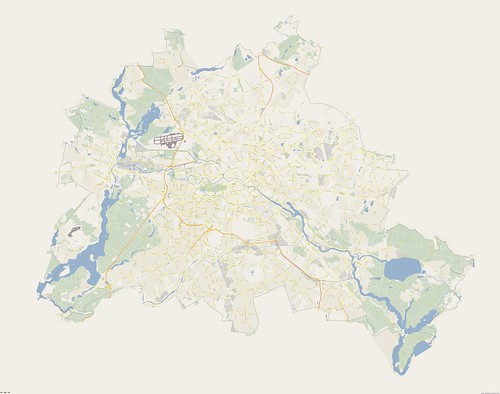
I assume by "50k" you mean "50 km"? Very rough calculation: that would result in a map with a scale 1 : 20,000 - 40,000 (depending on the size of your wall). So theoretically you could display street names (in small fonts though). The real problem is the total size of the area. The only real option would be to generate a large bitmap (Maperitive can do this), but it will not be of a good printing quality. Vector file like SVG would probably be too big for Illustrator or Inkscape to handle. The largest SVG I worked with so far was of Dublin and surroundings and it is quite hard to load and edit in Illustrator. An alternative is to split everything into several smaller rectangles and then print separately & glue together. You can do that in Maperitive, either as a bitmap or as SVG. A sample Berlin map made with Maperitive (but you need something in smaller scale): http://www.flickr.com/photos/breki74/5406882795/sizes/l/in/photostream/ (click on the "Original Size")
what structions do you use for produce this image?
(28 Apr '11, 12:29)
somenxavier
2
Download Berlin OSM data from Geofabrik. Load it into Maperitive and switch to Google Maps rules. Export to bitmap using the export-bitmap command (http://maperitive.net/docs/manual/Commands/ExportBitmap.html).
(02 May '11, 19:03)
Breki
|
|
There is now also a German company that produces maps of bigger areas based on OSM data, but you have to pay for their service and work: http://geodressing.de ... (also listed at Commercial_OSM_Software_and_Services) Maybe you can ask there in English es well. |
|
I am fairly sure this is not possible unless its a very barren area.most places would have thousands of street names in an area that size so the print would have to be very small, or have you got a very very big wall, sorry you will have to change your aims a bit. 2
following my answer a map 2.4 by 1.2 metres would give a 50k to 1 scale so a 100 metre street would scale to 2 millimetre not space for the name, In the UK the Ordinance Survey 50K maps only label a few roads.Hopefully this explains some of the practicalities of what you are trying to achieve.
(03 Mar '11, 12:58)
andy mackey
|
|
You (or someone else in a similar situation) might also want to consider
|
|
I have three semi serious solutions as I think it's impossible:-
|

